OUSE AND DERWENT PROJECT
In 2016 planning started once again. This time we had Paul Durdin on board as one of the professional archaeologists-
Our project this time was almost wholly archaeologically based. We had answered serious archaeological questions with our earlier work and also demonstrated that we had the expertise and volunteer workforce to undertake a much more complicated and wide-
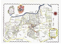
Permission had been obtained from three landowners: Site 1 at North Duffield was on Hugh Field Lane and I had been interested in this site from the start because there was what appeared to be a double ditched trapezoidal shaped enclosure containing a roundhouse ring ditch equally as big as the one we excavated at Park House Farm in our earlier project. In fact, the two roundhouses are only 300 meters apart; Site 2 was at West End Farm, Wood Hall just outside Hemingbrough and my attention had been drawn to this by excavations ahead of clay extraction at a quarry in Hemingbrough which had revealed an industrial Iron Age site; Site 3 was at Hard Moor Farm, Wheldrake mainly because the landowner is a friend of Jon Kenny and Jon has had a continued interest in the area of Wheldrake Woods.
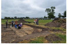
The intention, weather and crop patterns permitting was to excavate these three sites in the order 2,1,3. Due to the fact that we needed to conduct one excavation in each of the three years of the project and we had to take into account possible bad weather in future years, it was necessary to conduct our first dig at Hemingbrough in the autumn of 2017. Advertisements went out and our usual trusty volunteers turned up together with a strong group of both post graduate and student archaeologists from York University.
The dig took place from 30th September to 14th of October. In total, in excess of 80 people volunteered for the excavation, not, of course, all at the same time. We had a small disaster in that the large marquee, the small marquee and the toilet tent all blew down in the first few days in high winds overnight, the large marquee damaged beyond repair. I was able to repair the small marquee and we had to hire a marquee commercially which was expensive. I bought a new toilet tent and in time repaired the old one.
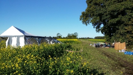
This image shows the damage-
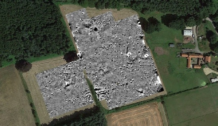
The geophysics for the site was remarkable, Due to the fact that we had been badly let down by the company from whom we had intended to buy the magnetometer, we were obliged to hire one.

This image shows the magnetometer data. We decided to put trial trenches over the black and white feature (top left), the feature top centre, the linear ditch, and two roundhouse ring ditches. We also put in another trench to check for a doorway and continuity of the ring ditch.
The black and white dipole response in the top left corner, Trench 1, eventually turned out to be two buried oil drums! But, in the trench we found a number of pre-
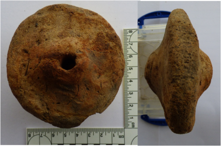
This item has been described at a loom weight or pot lid.
This artefact has been almost certainly identified as a loom weight. It is made of poorly fired clay, has a hole through the top, is pyramidal in shape and has a grove either worn or made in the narrow end near the hole.
The above item was one of two complete weights recovered from the site together with parts of further similar weights. In addition fired clay, possibly from the walls of a roundhouse or kiln lining, animal bones and granulated deposits that may turn out to be either bog iron or iron pan.
The bone recovered has been identified as deriving from cattle, sheep or goat, pig and red deer which gives an indication of the diet on this site. Red deer being present is unusual whilst the absence of horse bones is also seen as unusual.
Interestingly, when soil samples were later processed, hammer scale was found to be present. This is created when iron is being ‘worked’ by beating with a hammer and bits of metal fly off. So it is highly likely that iron was being both smelted and forged on site.
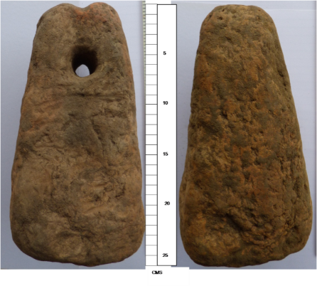
A total of 14 pieces of flint were recovered but only three of these showed evidence of having been ‘worked’. The first piece was a core rejuvenation flake dated to the later Mesolithic, the second piece, a ‘core’, was assigned to the later Neolithic and the third piece, a flint to the Early Bronze Age. It is always difficult to be certain when only small numbers of items are recovered however. None of the three items show microscopic evidence of use.
Trench 5 was the most exciting in that it contained the ring ditches of two roundhouses, together with the doorway terminals and a deep Roman ditch. There were also some post holes and some post pads. Finds from this trench were Middle and Late Iron Age pot and Roman Pot.
Due to the cost of the hire of the magnetometer we decided to hire one for two weeks in 2018 and survey both sites 1 and 3. Site one presented some amazing results.
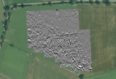
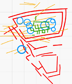
The geophysics for Site 1(North Duffield) shows the double ditched trapezoidal enclosure containing at least 9 roundhouse ring ditches plus others about the site, a possible drove-
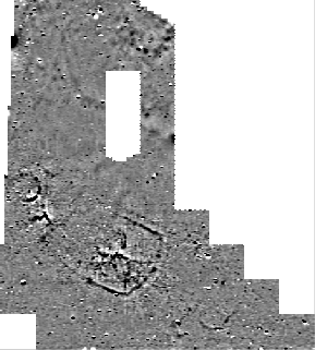
When we carried out the survey at Hard Moor Farm we did not get encouraging results. We could see some ditches but the ring ditch was unclear. However, there did appear to be the footprint of a building across a hedge line and not respecting that hedge-
Google maps image of site overlain with geophysics data
Since this site did not appear to meet our research agenda, permission was sought from HLF to look for another site. Two other sites have been identified and permission from the landowners obtained. After consideration, we decided that Cannon House Farm was the most interesting site and was more appropriate to our research questions. In the meantime, we resolved to investigate Site 3 with a limited excavation. At the end of May 2018 we opened up three small trenches, later followed by two more.
Trench 1 was in the general area of where the ring ditch was thought to be. In fact, a linear ditch, visible in the geophysics and crop marks, was confirmed as being of an Iron Age date from which pottery was recovered and one rather nice flint tool has now been assigned to the Later Neolithic to Early Bronze Age although one flint alone is not a good representation from which firm conclusions may be drawn.
Trench 2 was a little speculative as it was based upon a very large piece of iron slag or bog iron visible on the surface at the very edge of a ditch. The lump returned a weight of 6.9kgs. On excavation, we discovered a ditch which may be a ring ditch and this contained more iron slag, Iron Age pottery and some flint. This was not apparent in crop marks. We also found what may be kiln lining.
Trench 3 was opened over the geophysics anomaly that we thought might be a building. It turned out to be an enclosure ditch and Trench 5 was opened to confirm this. The enclosure was possibly 15m across and contained a lot more iron slag including what looks very much like kiln lining and plenty of big rim sherds of Iron Age pottery.
After consideration, we decided that Cannon House Farm was the most interesting site and was more appropriate to our research questions.
Trench 4 was opened on the Sunday mainly because we had too many volunteers for the remaining work that needed doing given that Trench 1 had been completed. This trench and Trench 2 were really hard work due to a thick overlay of clay, nevertheless there were some significant finds.
The site has dated, on the ceramic finds, to the period from Middle Iron Age 300BC to the early Roman period 2-
In addition to the ceramic assemblage, already mentioned iron slag et al were recovered, three flint items, some bone of which some was burnt and charcoal. Three pieces of worked flint were recovered: a hinged linear flake, a fragment of an irregular flake core and a facetted hinged and notched flake all dated to the late Neolithic-
Apart from the archaeology element of the Ouse and Derwent Project we have been creating a filmed record of the day-
On the subject of Social Media, this has been used as the main method of choice to disseminate information on progress of the Project and advertising future events. It has proved a very efficient and effective way to reach out to the community.
Workshops have, so far, been at North Duffield and Wheldrake village halls and the Regen Centre, Riccall on – OASIS recording system of reporting archaeological activities, Geophysical Survey, Desk Based Survey (research into previous intelligence on each of the three sites), osteology (study of animal bones) finds processing, finds post-
Our staff have already visited local schools in Bradford, Wheldrake, Riccall and North Duffield delivering lessons on the Iron Age and allowing children to visit one of the excavation sites. We are also continuing to work with our previous partners in delivering opportunities to groups and individuals disadvantaged by disability and conditions that otherwise would preclude them from taking part in activities. This is, indeed, a very important part of our remit to be inclusive in all that we do. We are currently working with adults with learning and physical disabilities and a group of children being educated at home by their parents as an alternative to State education, and we look forward to running further courses before the Project ends.
Finally, when all the elements of the Project have been completed, we will be making reports to the Heritage Environment Record and the Archaeological Data Service as well as archaeological journals and giving presentations to local groups. We will also produce a booklet detailing our work for supply to the domestic market.
For this project we created and used a digital Context Card based on the use of a tablet. For the dig at Hemingbrough we backed everything up on paper but, when that worked faultlessly, all future excavations went paperless. We are happy to make this process available to other groups. Just email us for further details.
This image is our understanding of the geophysical survey of the Hugh Field Lane site, North Duffield showing the various ring ditches, two double ditched trapezoidal enclosures and a possible Roman building superimposed on top of that.
Once again, 6 trenches were opened up in an attempt to ground-
The northern enclosure proved to be substantial structures which would have looked really imposing when the soil removed from the ditches was piled up making banks either side of the two ditches. Clearly, these were intended to send a message to all-
A total of 35.3kg of iron working material was recovered from the various features. The vast majority of the slag from the site is smelting slag, being dense with charcoal impressions, or attached furnace lining. There is no tap slag present on the site, so it is highly likely that the furnaces were non-
Very little bone survived as conditions in pre-
The ceramic assemblage consisted of 688 items of which 665 were identified as pottery dating from the Middle Iron Age to the late Roman period, so this site was in existence for perhaps 600 years.
There was more Roman pottery than pre-
Our final dig of the Project would be at Cannon House Farm, Wheldrake as we had decided that this site most appropriately fitted our research questions was conducted in 2019. Geophysical survey earlier in the year provided interesting and exciting features confirming our aerial photographs and drone images.
Once again we had a double ditched enclosure,this time sub-
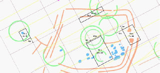
The image is, once again, a representation of what is thought the geophysics and drone images reveal. Red lines are the enclosure ditches, green the ring ditches and the black rectangles indicate the four trenches that we opened up
Trench 1 investigated the out-
Whilst we had experienced high winds in our two preceding years, causing damage in both years, 2019 was a dig to remember. We lost two days to rain completely and we lost count of the number of times we had to bail out the trenches and features, sometimes several times a day, thereby losing even more time. Such was the disruption that we did not excavate any feature in Trench 2 nor the opposite terminals of the doorway in Trench 4. We were obliged to dig drainage ditches to protect the floors in the marquee and most of our volunteers suffered trench-
Apart from that, the dig was highly successful. Trench 1 yielded more than half the total assemblage of pottery. It was designated a training trench and therefore the adults with learning disabilities and the home educated children and their parents were guaranteed to ‘find’ something. The ring ditch that was uncovered was packed from base to the top with a mixture of fire-
Just over 800 sherds, in total, were recovered including the handle and upper part of a amphora(container for wine, olive oil or fish sauce) from the Mediterranean, an almost complete bucket-
This site was atypical of the other sites we have excavated in the almost complete absence of iron-
First indications are that this site is slightly later than Hard Moor Farm as the majority of the ceramic assemblage to our inexperienced eye seems to be Roman. Once again, could this site be a part of the supply chain for feeding the Garrison in Eboracum?